History · Weedhaven & Carancahua Bay
The stories before our address.
Explore the coast, the Keller grant, the ranch and the routes that connected this place. The records distinguish our particular acreage from the surrounding community.
Choose a chapter below. Each opens in place; numbered citations lead to the source notes at the end.
01 · The coast and the Keller grant
Carancahua Bay: the bay before the address
A lot line gives us a precise place to begin a house. The bay gives that place a wider setting.
Carancahua Bay is an inlet of Matagorda Bay, with the Jackson–Calhoun county line extending through it. Port Alto lies on its western shore and the community of Carancahua on the eastern shore. The bay’s name preserves a connection to the Karankawa people who lived along these shores.[5]
The Karankawa world extended along the Texas Gulf Coast. Fishing, hunting, gathering, and seasonal movement between the mainland and barrier islands were central to life here. Shallow water was a route as well as a source of food; dugout canoes carried families and their belongings.[6]
That history also includes displacement and violence as colonization transformed the coast. It should not end with the old claim that the Karankawa simply disappeared. The Handbook of Texas describes surviving descendants and the Karankawa Kadla’s continuing cultural and preservation work.[6]
None of that establishes an archaeological site on our lots. It does establish that the history of this coast reaches much farther back than the written ownership records we have found. The 1830 Keller grant belongs inside that larger history, rather than serving as its beginning.
The bay also appears in the neighborhood’s more recent public record. An August 2013 U.S. Army Corps of Engineers notice describes the association’s application concerning existing walkways and a pier, plus proposed shoreline works. That notice is evidence of an application, not proof that every proposal was approved or built.[7]
Our plans for porches and an upstairs balcony are part of our own response to this setting. As the house takes shape, we want the journal to keep looking outward, too: at the bay, the neighboring land, and the history carried in their names.
When our land was part of Mexico
One of the most revealing things about our land is the date on the title behind its parent survey: March 3, 1830. Texas was part of Mexico then. The title behind the Keller survey was issued under Mexican authority, six years before Texas declared independence and fifteen years before statehood.
That changes the way we read our address. The story does not begin with an American government opening a new neighborhood. It begins with an older coast, a young Mexican nation, and a document that still helps identify the land today.
Before Mexico: a Spanish frontier on an Indigenous coast
Before Mexican independence, Spain claimed Texas as part of its North American empire, New Spain. Spanish claims and institutions were laid over a coast already inhabited by Indigenous peoples. The bay did not become a place with a history only when a European government put it on a map.
The Spanish presence in this wider coastal region included missions, military posts, and ranching. Mission Espíritu Santo was established near Matagorda Bay in 1722 and moved to the present Goliad site in 1749. Its cattle operation became an important part of the colonial ranching economy.[8] These were regional institutions; we have not found evidence of a Spanish mission or presidio on our two lots.
1821–1825: Mexico inherits Texas and invites settlers
Mexico won independence from Spain in 1821. Texas became part of the new country and, in the federal system of 1824, joined Coahuila as the state of Coahuila y Texas. Its own state constitution followed in 1827.[9]
Mexico wanted more settlement, farming, trade, and security in its northern territory. It continued a colonization program in which empresarios recruited and supervised qualified immigrants. Stephen F. Austin became the best-known of those agents. The movement of settlers from the United States into Texas during these years was immigration into Mexico.[10]
Federal colonization legislation in 1824 and the state’s law of March 24, 1825 supplied the framework for much of that settlement. Government land commissioners issued titles, while empresarios helped organize the colonies. Promises of land drew families, but the process also brought disputes over authority, immigration, and whose rights would be recognized.[11]
1830: Austin’s signature on the Keller title
The grant file makes that Mexican connection visible. Its title page is in Spanish. The printed heading names Estévan F. Austin and describes his authority from the government of Coahuila and Texas. Francis Keller’s name is entered into the form, and Austin’s signature appears below the title dated March 3, 1830, at San Felipe de Austin.[12]
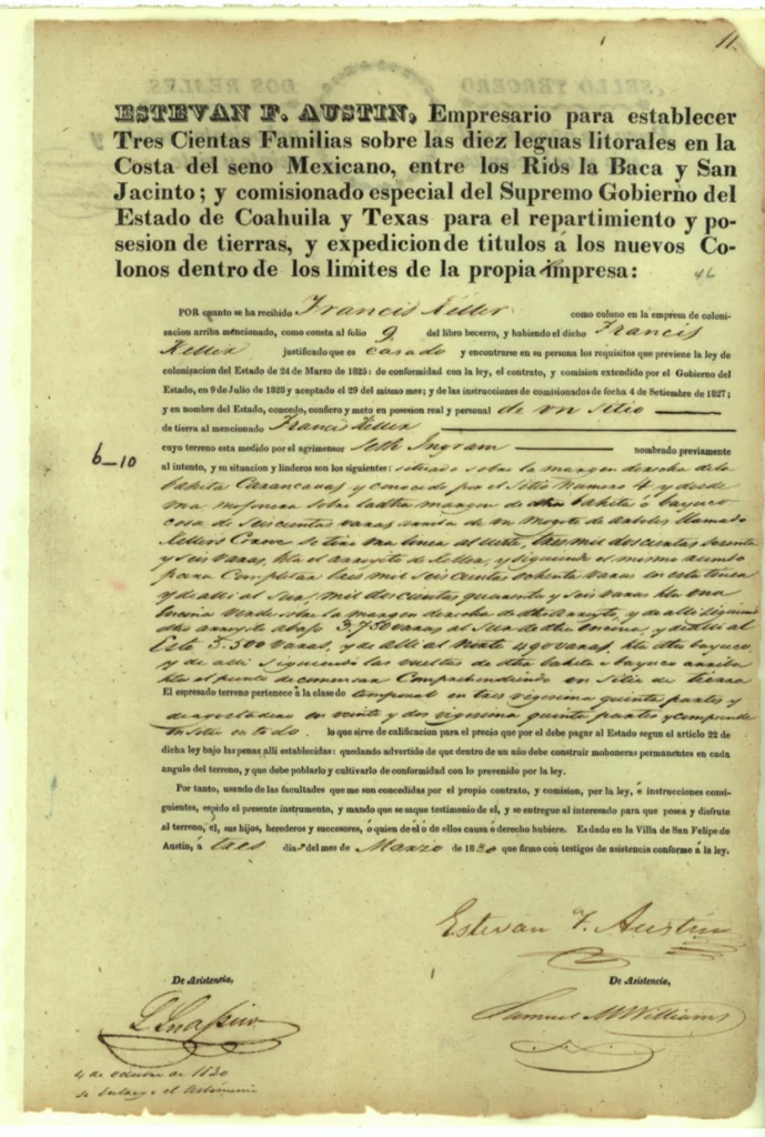
The language can be misleading at first: a document written in Spanish is not necessarily a grant from Spain. This one belongs to independent Mexico. Austin was acting within that Mexican system when he signed it.
The land office lists 4,428.4 acres for the grant—approximately one league. Our subdivision’s description, Francis Keller League 4, Abstract 37, points back to that larger survey. Our present 10.36 acres are a small part of the landscape described by the older record. The grant does not identify the modern lots, and Austin’s signature is not evidence that he personally visited our home site.
Before the title: a family’s petition and a surveyor’s sketch
The paperwork now takes us back a little farther. In the Land Office’s historical English translation, Francis Keller’s petition is dated December 29, 1829, in the Town of Austin. He describes arriving with his family and asks for a league on Carancahua Bayou. That puts a family and a request behind the formal title: someone was seeking a place in this coastal landscape before the document was signed.[23]
Next comes the survey. Seth Ingram’s English field notes are dated February 12, 1830, and include a sketch of the larger tract. Petition, survey, title: three separate steps over the winter of 1829–1830, all within Mexican Texas. The English title translation was certified by Wm. Sevey in 1841; it is itself a historical record, made eleven years after the grant.[23][24]
These pages bring us closer to the beginning of the parent grant’s documented story. They still leave a very human question open: where did Keller’s family actually live? Neither the petition nor the sketch places their home inside our present two lots.
1835–1836: a political break, with lasting consequences
During the early 1830s, disputes sharpened over immigration, land, slavery, and the balance of power between Mexico’s states and national government. The move toward centralized government under Santa Anna helped turn those disputes into rebellion. People of Mexican descent in Texas—Tejanos—also had differing political loyalties; the conflict cannot be understood simply as two uniform populations facing each other.[11]
Texas declared independence on March 2, 1836. It then operated as the Republic of Texas. The change of government did not make the older Spanish and Mexican land records irrelevant. The new General Land Office collected, translated, and examined those records as it worked to determine valid titles and available land.[13, 14]
Independence also changed who could claim citizenship and opportunity. The Republic’s 1836 constitution protected slavery and excluded Indigenous people and people of African descent from its general citizenship provision. Those restrictions belong in the land story, alongside the familiar account of independence.[15] We have not established who lived or worked on our particular acreage during that period.
1845–1848: statehood, war, and a new international boundary
Texas entered the United States on December 29, 1845. The formal transfer of government followed on February 19, 1846. Mexico had not accepted the loss of Texas, and annexation was one of the disputes that led to the U.S.–Mexican War.[13]
The Treaty of Guadalupe Hidalgo, signed February 2, 1848, ended that war. Mexico relinquished its claim to Texas and recognized the Rio Grande as the boundary with the United States. The treaty also transferred a vast area farther west.[16]
For our property’s timeline, the distinction matters: Texas became a U.S. state in 1845; the treaty settled Mexico’s claim in 1848. Our acreage was already within the Texas that had joined the Union, rather than becoming American for the first time with the western territorial transfer.
Why the Mexican chapter still belongs in our story
Governments changed, but the earlier survey remained part of the way people described this land. That is why an 1830 title and a twenty-first-century subdivision can appear in the same line of research.
We still need the intervening deeds to trace each owner between Keller’s grant and the Weed-family ranch. What we can already see is a concrete connection between our home plans and Mexican Texas: the larger survey named in the subdivision records leads back to a Spanish-language title signed under Mexican authority.
When we look at the land now, we are looking at a place that has been described within several political worlds. Learning that history gives our new chapter more depth—and leaves us with better questions to ask next.
02 · Weedhaven, the school and the ranch house
Weedhaven: the name before the neighborhood
Small places do not always leave a courthouse square or a row of old storefronts to explain themselves. Sometimes their history survives in a name, a family photograph, a recollection, or a few lines in a deed. Weedhaven is one of those names we want to keep in our story.
The Handbook of Texas places the community at State Highways 35 and 172 in southern Jackson County. Its account begins with a McHaney family ranch in the 1920s, followed by ownership by J. F. Weed. Its account places the Weedhaven name at the crossroads by the mid-1940s. A contemporary newspaper now takes our dated evidence back to 1938, as the ranch-house chapter below explains.[1]
By the 1950s, the little community served people traveling the coast. George McHaney operated a grocery, icehouse, and filling station; a cafe and motel accommodated fishermen and other visitors. It was a place to get the practical things that made a coastal trip possible—food, fuel, ice, and somewhere to stay.[1]
That is the crossroads story. The ranch story is related, but it deserves its own evidence. Our neighborhood association says Sunrise Bay was created from part of Weedhaven Ranch. Thomas H. Weed’s obituary remembers that family ranch on Carancahua Bay through hunting, fishing, and holiday gatherings.[2, 3] Taken together, these accounts give the name a human scale: work and travel at the highway, family life and outdoor traditions at the ranch.
We should not move those scenes onto our own ten acres without proof. We have not established that the store, school, ranch house, or other old buildings stood on our lots. The local genealogy archive includes photographs identified as Weedhaven School around 1932, but a photograph of the community is not a site map of our property.[4]
For us, the name is a reminder to look beyond the subdivision boundary. Sunrise Bay is the neighborhood we are building in; Weedhaven is part of the landscape we are learning to understand. Keeping both names in the journal lets the new chapter sit beside the older ones.
Before Weedhaven: following the Midway name
Following an old place means following its changing names. Our research now has another one to keep beside Weedhaven: Midway. In the newspaper columns preserved by Jackson County’s genealogy archive, that name appears alongside the McHaney family before the years usually associated with Weedhaven.
A transcription of the Edna Weekly Herald dated February 20, 1936 repeatedly places George McHaney’s home at Midway. The June 10, 1937 column also identifies George and his wife with Midway and describes relatives visiting them, including a visit that involved fishing. A March 24, 1932 column records a gathering at C. C. McHaney’s home, although it does not locate that house. These are small notices about ordinary life, but they give us dated names and relationships to follow.[17]
The school photographs add another human connection. Their archive caption dates them to about 1932, identifies Eugenia Hopper as the teacher, and says she boarded with the McHaney family. Her niece, Zia Miller, supplied the pictures.[4] Knowing who supplied a photograph helps us trace its history, even when the caption leaves its precise location unanswered.
A school offered for sale in 1946
A contemporary notice brings us closer. The Edna Weekly Herald of March 28, 1946 advertised the B. F. Ward School building, District 15, for sale. It placed the building a quarter mile south of Midway Store and directed bids to Mrs. George McHaney there by April 6. We checked the scanned newspaper itself, not just its automatically extracted text.[20]
That combination of a school name, a location description, and a McHaney connection makes B. F. Ward a strong candidate for further comparison with the photographs labeled Weedhaven School. It does not yet establish that they show the same school. The notice also leaves the purchaser, any later move, and the land ownership unanswered.
The State Archives holds a county highway map prepared from the 1936 survey and revised to February 1, 1940. Its legend distinguishes schools, businesses, dwellings, and farms. An unnamed school symbol appears north of Highway 35 near its junction with Highway 172. Our present lots lie south of Highway 35. This comparison helps us read the map without moving its buildings onto our land: the symbol does not name B. F. Ward, identify the school in the photographs, or establish a school site on our lots. The county map is not a parcel survey.[21]
The district’s next chapter: Palacios, 1949
The state’s school-district index supplies another dated connection. Its Jackson County and Matagorda County entries record B. F. Ward District 15 consolidating with Palacios Independent School District, alongside Carancahua District 12 and Deutschburg District 20, effective September 1, 1949. Palacios became a district spanning the two counties. Both entries point to state file S2058.[22]
This is the later history of the district. It does not tell us when classes last met in the building advertised for sale in 1946, whether that sale went through, or where the building went. It does give the research a more precise destination: the underlying consolidation file and any surviving records held by Palacios.
A school name still to establish
The archive labels the photographs “Weedhaven School,” while the Handbook of Texas says the crossroads was known as Weedhaven by the mid-1940s.[1, 4] The school caption may use the later community name for an earlier place. That is a possibility, not a settled explanation. The 1946 notice gives us B. F. Ward and District 15 as a concrete lead, but the name and district of the photographed school in 1932 remain unverified. The Midway references do not by themselves establish that it was called Midway School.
From family captions to county records
There is a specific paper trail to pursue. A 1980 courthouse inventory lists school-board minutes covering 1915–1955, a county school census record covering 1923–1966, and school financial records covering 1927–1950 under the County Judge’s school records. These are historical holdings descriptions; their present custody and survival still need confirmation.[18]
State archives also describe district-history cards and district action files, some containing maps. Those could identify the relevant district and its changes, although a district boundary is not the location of its schoolhouse.[19] The next connection we need is between a named school, a dated site record, and land that can be located on a survey. Until then, this is a story of the surrounding community, with the question of its buildings still open.
A ranch house that helped boats find their way
We began with a simple question: what did the old Weed ranch house look like? A coastal survey supplied a detail we had not expected. In 1935, the U.S. Coast and Geodetic Survey recorded a two-story frame ranch house with a privately maintained electric navigation light on its roof.[28]
That gives the house a place in the working life of the bay. For someone on the water, its roof carried a useful point of reference. For us, looking backward from a new house plan, it is a reminder that an older home could also serve people beyond its own gate.
The survey marks the house-area point near the shore. In our earlier map comparison, that point lies east of our modern lots. We have not placed the ranch house on our acreage. Immediately beside the mapped point, a short line projects from the shore. It could represent a pier or another waterfront feature, but its meaning has not been confirmed. The report describes the house and light without identifying a dock or a commercial port.
So our dock question remains open. We are looking for an authenticated photograph or painting of the coastal ranch house, along with images of the older store and surrounding area. The school photographs already linked in this chapter show another part of community life; they cannot stand in for a picture of the ranch.
The name was in print by 1938
The November 10, 1938 Palacios Beacon gives us an earlier dated appearance of Weed Haven. Its account of a well celebration describes Weed’s ranch home on the west bank of Carancahua Bay and reports that he had come to Jackson County about ten years earlier to raise Hereford cattle.[29]
This sharpens the timeline: the name was in use by 1938. It does not date a naming ceremony or establish when the ranch land changed hands. Those are questions for the deeds.
03 · Mail, roads, the ferry and the bridge
Before our mailbox: when mail connected the bay
We began by asking what stood on our land. Following the records has opened another question: how did people around the bay stay connected? A post office file turns out to be a small window into that everyday world. Its forms record distances, waterways, proposed names, and the practical problem of getting a letter from one community to another.
In July 1878, L. Garrett signed an application for a Carancahua post office. An existing mail route already connected Texana and Deming’s Bridge once a week, and Garrett estimated that the proposed office would serve about 100 people. The following year, a report signed by Garrett as postmaster identifies an operating office and Route 31110. It gives Texana as about twelve road miles west and Deming’s Bridge as about eighteen miles east.[25]
Those distances make the coast feel different from the one we drive through today. They describe a community through its connections: the next post office, the watercourse nearby, the road a carrier would follow. A weekly service also suggests a different rhythm for news and correspondence. We do not yet know how that particular mail was carried, so the records cannot give us a stagecoach scene or a rider arriving at our gate.
A wharf, a proposed name, and changing addresses
The later papers preserve names that could easily disappear from a modern map. In 1897, Ashby W. Lewis applied for an office associated with Lewis’ Wharf on the eastern side of the bay. On the reverse of his application, he described level prairie, a county road, two streams, and a bridged river. He argued that a suggested connection with Edna and Red Bluff could be traveled as a round trip in a day. It was his case for a proposed mail connection; we have not established that the route was adopted.[25]
A 1909 application has another revealing detail: the proposed name Cheeseburg is crossed out and Carancahua written in. The same paperwork identifies the village to be supplied as Freeport. These names belong to the bay’s postal history; they are not evidence that Sunrise Bay Drive or Weedhaven once carried those names.[25]
By 1911, Simon Neff’s proposed site change referred to a Carancahua–Palacios mail contract, Star Route 50982, operating three times weekly. In 1922, Fluke Frankson proposed moving the office half a mile north, from leased premises to a place he owned on the bay’s eastern side. The requests show people trying to make a small public service work around roads, property, and distance. They do not, by themselves, prove that each requested move happened.[25]
Carancahua’s postal community and the Weedhaven crossroads need their own places in this story. Their histories help explain the wider neighborhood of our home, but no post office or mail stop has yet been placed on our ten acres. What the papers do give us is a more personal coast: Garrett, Lewis, Petersen, Neff, and Frankson, each leaving a name in the effort to keep people connected.
The road before the street name
One question has stayed with us: was Sunrise Bay Drive called something else before it became part of this neighborhood? The older maps give us part of an answer. There was a road toward the bay well before the subdivision. Its earlier name remains unknown.
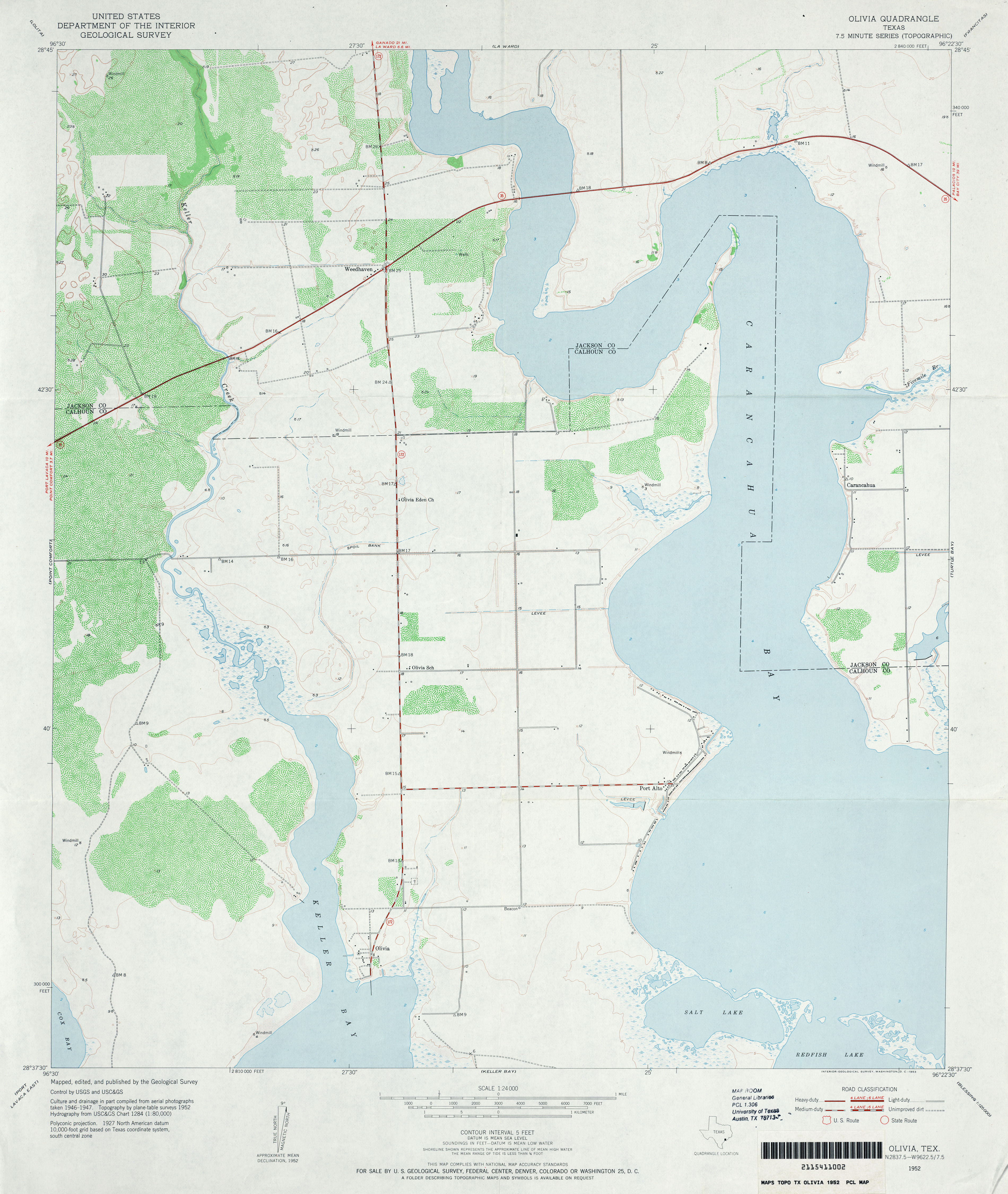
On the 1952 U.S. Geological Survey Olivia quadrangle, Weedhaven is already labeled at the highway junction. South of that junction, an unnamed road runs east from State Highway 172 toward a group of building symbols near Carancahua Bay. It is an intriguing earlier approach to the same broad bay-side landscape.[26]
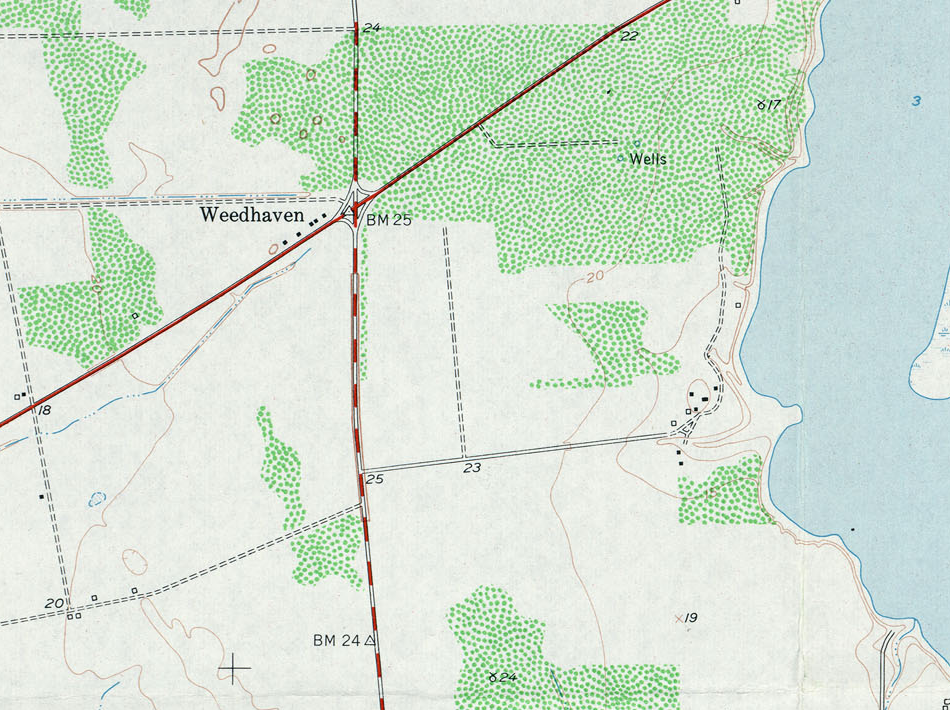
We cannot yet trace that line onto today’s Sunrise Bay Drive with confidence. A road in the right general direction is a useful lead, but bends, junctions, and later surveys still have to be matched. The little building symbols do not name their occupants or tell us their purpose, and none has been established as a building on our parcels.
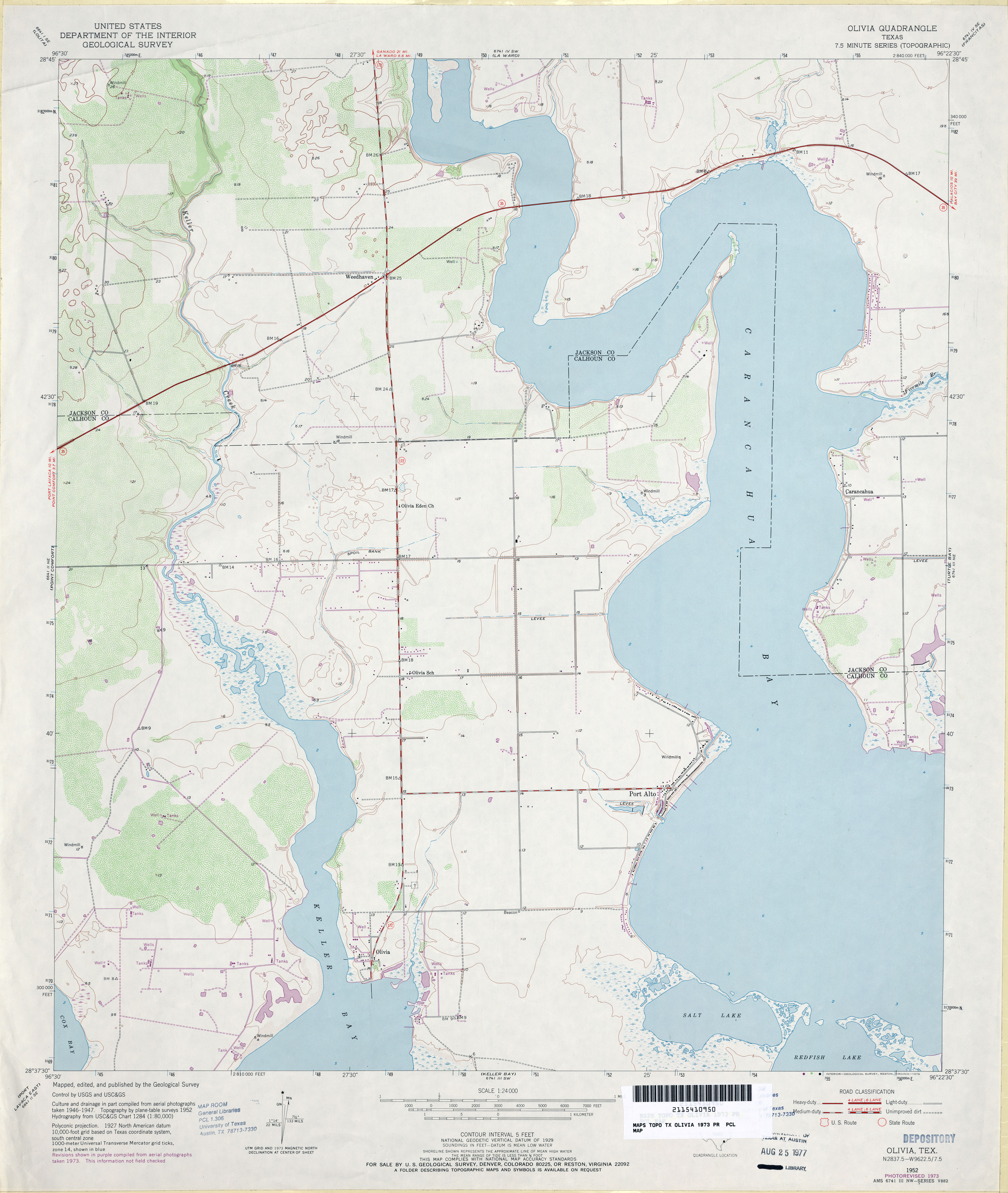
The map also carries more than one moment in time. Its topography was surveyed in 1952, while some road, building, and drainage information came from aerial photographs taken in 1946–1947. The 1973 edition revises that same base using later aerial photography. Its purple revisions were not field checked, and a retained black symbol does not prove that a building was still standing in 1973.[26][27]
For now, that unnamed road is a thread worth following. It helps us picture a landscape organized around reaching the bay before there were subdivision lot numbers. As we work backward from our address, the next step is to connect those older lines to the deeds and surveys that gave the neighborhood its present shape.
A ferry, a bridge, and the way around the bay
Old maps change the way we read a familiar drive. The water we cross in minutes once posed a practical question: where could a road go, and how would people get across?
On the 1952 USGS La Ward quadrangle, a ferry is labeled across East Carancahua Creek near the creek junction, upstream of the Highway 35 bay crossing. That is a real mapped ferry, but we do not yet know who ran it, whether it was public or private, or when it began and ended service.[30]
The ferry and the bay bridge occupy different locations. We cannot turn them into a neat succession in which one simply replaced the other. The county highway map revised to February 1, 1940 already shows Highway 35 crossing the bay, while the later USGS map records the upstream ferry.[21]
A replacement planned before Carla
The next part of the story has a useful surprise. On April 7, 1960, the Edna Herald reported advance planning for a new Highway 35 bridge over Carancahua Bay near Weedhaven. Replacement planning was underway before Hurricane Carla struck.[31]
Carla destroyed the existing crossing in September 1961. The Herald of July 19, 1962 reported that the new causeway had opened the preceding Thursday at 3 p.m. That puts the reopening on July 12, 1962.[32] We have not yet established how the storm changed the earlier proposal, design, or construction schedule.
For our home journal, these crossings belong to the story of reaching this place. They connect the bay-side landscape to the communities on either side. The original bridge opening date and the ferry’s operating history are still chapters to fill in.
04 · Following the owners and the land records
Who held the land before us?
Following a place-name is one kind of research. Following the land from owner to owner takes a different kind of patience. A familiar surname is a starting point; the tract description is what tells us which land a document concerns.
That distinction has become especially important in the Weed records. The 1949 pipeline easement describes 1,386 acres in the Francis G. Keller Survey and a separate 1,360-acre tract in the J. D. Newell Survey. The similar acreages belong to different surveys and must stay separate.[33]
A later trust-distribution record supplies an exact older deed reference: a June 4, 1934 conveyance from Mrs. Maude B. Traylor to James F. Weed, recorded in Volume 89, pages 507 and following. Its 1,360 acres are in the Newell League. That reference helps us follow the family’s land dealings, but it does not establish Traylor as a predecessor owner of our Keller-survey lots.
The McHaney link still needs its deeds
The Handbook of Texas connects the community’s ranch history with the McHaney family and later Weed ownership. To answer how the Weeds obtained the land, and who held it before McHaney, we still need the relevant acquisition and transfer instruments. We also need to connect their legal descriptions to the later ranch, subdivision, and our two lots.
The complete 1959 partition is another important missing piece. Until those records can be read together, we have portions of the ownership story rather than an unbroken chain from the 1830 grant to Sunrise Bay. A deed for a nearby tract cannot fill that gap simply because a name looks right.
That leaves us with a clear next question, and a more careful way to ask it: which recorded instrument connects this particular ground to the next owner? We will add the answer when we can show the connection.
The land-record timeline so far
The entries below distinguish the history of our parcels from the wider grant and subdivision.
- Before 1821 — Spanish Texas
- Spain claimed this region as part of New Spain, on an Indigenous coast whose history predates those claims.
- 1821–1827 — Mexican Texas
- Mexico became independent in 1821; Texas joined Coahuila in the federal system of 1824. The combined state adopted its constitution in 1827.
- December 29, 1829 — Keller’s petition
- The historical Land Office translation dates Francis Keller’s request for a league on Carancahua Bayou to this day.
- February 12, 1830 — Ingram’s survey
- Seth Ingram’s English field notes and sketch document the survey of the parent tract.
- March 3, 1830 — The larger grant
- The General Land Office dates Francis Keller’s Jackson County Abstract 37 title to this day. Its record lists survey 4 and 4,428.4 acres. Our subdivision documents identify the Keller League 4 as the parent survey.
- March 2, 1836 — The Republic of Texas
- Texas declared independence. Earlier Spanish and Mexican title records were collected and examined by the new land office.
- 1845–1848 — U.S. statehood and the treaty
- Texas entered the United States December 29, 1845. The February 2, 1848 Treaty of Guadalupe Hidalgo ended the U.S.–Mexican War and settled Mexico’s claim to Texas.
- 1949 onward — Weed-family record references
- Our title materials cite a 1949 W. F. Weed easement and later utility, pipeline, mineral, and estate instruments. These are clues to the larger tract’s history, rather than a complete chain of surface ownership.
- January 11, 2007 — A conveyance cited in our title records
- Thomas H. Weed to Lone Star Land Partners, LLC; Jackson County Volume 297, page 49.
- June 11–12, 2007 — The recorded subdivision
- The association certificate dates the plat to June 11 and the original declaration to June 12. The development comprised 263 acres in the Keller league.
- January 28, 2013 — An earlier Lot 32 deed
- The Lot 32 title commitment cites a conveyance recorded in Volume 432, page 854.
- April 27, 2022 — Our Lot 32 purchase
- Our deed is dated April 27 and recorded April 29, 2022, instrument 2022-01279, Volume 661, page 589.
- January 29, 2025 — The adjoining Lot 31
- Our owner’s title policy is dated January 29 and identifies our ownership of Lot 31. The two parcels total 10.36 acres.
- 2026 — Planning our home
- The July architectural drawing set and subsequent concept images document the next chapter.
Read the fuller story of our land and the remaining research gaps →
Sources & record notes · 33 references
Sources behind our stories
- Laurie E. Jasinski, “Weedhaven, TX,” Handbook of Texas Online.
- Sunrise Bay Estates association, Property Information.
- Thomas H. Weed obituary, family remembrance published in 2017.
- Jackson County genealogy archive, Weedhaven information and school photographs. Photographs are linked to their source, not reproduced here.
- “Carancahua Bay,” Handbook of Texas Online.
- Carol A. Lipscomb, revised by Tim Seiter, “Karankawa Indians,” Handbook of Texas Online.
- U.S. Army Corps of Engineers, public notice SWG-2007-01891, August 29, 2013.
- Texas Parks and Wildlife, Goliad history: Mission Espíritu Santo and regional Spanish ranching.
- GLO guide to the Spanish Collection (PDF) and Texas Legislative Reference Library’s law timeline: Mexican independence, Coahuila y Texas, and its constitutions.
- Texas State Library, Anglo-American Colonization Efforts: immigration and the empresario system.
- Arnoldo De León, revised by Jesús F. de la Teja, “Mexican Texas,” Handbook of Texas Online: colonization laws and political conflicts.
- Original Francis Keller title file (PDF), page 3; GLO catalog record, Jackson Abstract 37, SC 000014:3. The title page was examined directly; the full handwritten file has not yet been transcribed.
- U.S. Department of State, Office of the Historian, Texas: declaration, recognition, annexation, and transfer dates.
- History of the Texas General Land Office: preservation and examination of Spanish and Mexican titles.
- Constitution of the Republic of Texas, General Provisions, sections 9–10, Tarlton Law Library: slavery and citizenship.
- National Archives, Treaty of Guadalupe Hidalgo: treaty text and historical context.
- Jackson County genealogy archive, LaWard newspaper columns from the 1930s: transcriptions dated March 24, 1932; February 20, 1936; and June 10, 1937. The original newspaper images for these three notices have not yet been checked.
- Riney, Fortin, and Saxon, Inventory of county records, Jackson County Courthouse, Edna, Texas (1980), page 205: historical listing of County Judge school records.
- Texas State Library, Texas Education Records and Research Resources; Texas Education Agency historical school district action files finding aid. Collection descriptions identify research routes; the Jackson County cards and underlying school-site records have not yet been verified.
- Edna Weekly Herald, March 28, 1946, page 4: school-board trustees’ notice offering the B. F. Ward School building for sale. Newspaper scan examined directly.
- Texas State Archives map 04903, General Highway Map, Jackson County: prepared in 1936 and revised to February 1, 1940. Map and legend examined directly.
- Texas Education Agency card file, S-file index, Texas Digital Archive, accession 2018/011: Jackson County card 3 (viewer page 634) and Matagorda County card 2 (viewer page 762). Both entries were examined and cross-checked; they refer to file S2058. The underlying file has not yet been examined.
- Texas General Land Office, Translation of Titles — Austin’s First Colony, Vol. 2, document 94545: Keller entry, manuscript pages 36–37 (PDF pages 37–38), including the December 29, 1829 petition and Wm. Sevey’s June 30, 1841 certification. Historical translation examined directly.
- Texas General Land Office, English Field Notes of the Spanish Archives, Book 6, document 96532: Seth Ingram’s Keller survey, February 12, 1830, manuscript page 10 (PDF page 7). Entry and sketch examined directly; the catalogue’s volume date is distinct from the entry date.
- National Archives, Record Group 28, Reports of Site Locations, Texas: Hunt–Jackson, M1126 Roll 579, file unit 68756260: frames 0748–0749 (Garrett, 1878–1879), 0746–0747 (Lewis, 1897), 0744–0745 (Petersen, 1909–1910), 0742–0743 (Neff, 1911), and 0739–0741 (Frankson, 1922). Original scans examined directly. Application populations are estimates; proposed names, routes, and moves are not treated as approved actions.
- U.S. Geological Survey, Olivia quadrangle, Texas, 1952, scale 1:24,000, University of Texas Libraries, Perry-Castañeda map collection. Map and marginal notes examined directly; the illustration above is a crop of this public-domain map.
- U.S. Geological Survey, Olivia quadrangle, Texas, 1952 base photorevised 1973, scale 1:24,000, University of Texas Libraries. Map and marginal notes examined directly. Purple revisions from 1973 aerial photography were not field checked.
- U.S. Coast and Geodetic Survey, T-04927 descriptive report, 1935, scan page 4: ranch-house structure and roof light. The corresponding survey map was examined in our research; the projecting shore feature remains unidentified.
- Palacios Beacon, November 10, 1938, page 1, report on the Weed No. 1 well celebration. Original scan examined in our November 8 research. The reported arrival interval is not a deed date.
- U.S. Geological Survey, La Ward quadrangle, 1952, published 1953, University of Texas Libraries: ferry labeled on East Carancahua Creek. Operator and service dates remain unverified.
- Edna Herald, April 7, 1960, page 1: advance planning for a new Carancahua Bay bridge. The proposal has not yet been compared with the final replacement design.
- Edna Herald, July 19, 1962, page 12, reopening report. July 12 follows from the report’s reference to the preceding Thursday.
- Jackson County Deed Records, Volume 185, pages 617–620 (1949 pipeline easement); Volume 266, pages 430–433 (1956 additional easement); Volume 633, page 726, Exhibit B, Tract Fourteen (1983 trust distribution). Original scans examined in our research. The 1934 deed cited by the later record has not yet been obtained. The McHaney acquisition, McHaney-to-Weed transfer, and complete 1959 partition remain unresolved.

Land-record timeline: GLO Abstract 37 record; recorded association certificate; and the parcel documents described in our land story’s record notes.
Original stories for our home journal, expanded November 9, 2026. Regional history, association recollections, and parcel records have different scopes; the complete ownership chain is still being researched.